| Visitors | New Residents | Events | Business Directory | Civic Info | Airport Info | Contact Us |
Rental Properties
Associated Companies
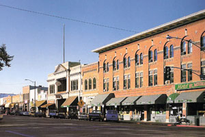
Visiting Prescott
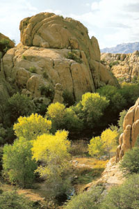
 This information has been gathered to help you find out what is going on in Prescott. There is so much to do here in our fair city that we can't include everything. However, we have tired to include those things that make Prescott "Everybody's Hometown". You will be enchanted by the beauty Prescott offers: from superbly designed golf courses to numerous rugged hiking trails; from shady tree lined parks to picturesque mountain lakes; from old West museums to modern performing arts. Visit Prescott today and enjoy all we have to offer.
Prescott Area Chambers of Commerce back to the top
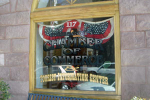
- Prescott Chamber of Commerce
117 W. Goodwin Street
Prescott, AZ 86303
1-800-266-7534 - Prescott Valley Chamber of Commerce
3001 N. Main St., Suite 2A
Prescott Valley, AZ 86314
928-772-8857 - Chino Valley Chamber of Commerce
448 N. Highway 89, Suite I-J, Chino Valley, AZ 86323
928-636-2493
Prescott Area Performing Arts back to the top
- Blue Rose Theater
115 S. McCormick Street, Prescott, Arizona
928-541-9362
bluerose914@juno.com
www.sharlot.org
The mission of Sharlot Hall Museum's Blue Rose Theater is to present well researched, historical theater in an environment that enhances the audience as well as the actor. - Prescott Fine Arts Association
208 North Marina Street, Prescott, Az.
928-445-3286
pfaadirector@qwest.net
www.pfaa.net
Producing theatrical performances, musical concerts and art gallery shows throughout the year featuring local talent. - Yavapai College Performance Hall and Arts Gallery
1100 East Sheldon Street, Prescott, Arizona
928-776-2033
Largest performance venue in Prescott featuring guest performances by world-renowned performing artists, the Phoenix Symphony and local groups. - Elks Opera House
117 E. Gurley St., Prescott, AZ 86302
928-443-8541
The theater seats 575 in a main floor and balcony and is available to rent for all types of activities, including theater productions, full screen film presentations, classes, seminars, reunions and weddings. - Tim's Toyota Center (Prescott Valley Convention and Events Center)
3201 N. Main, Prescott Valley, AZ 86314
866-772-1819
Tim's Toyota Center is a multipurpose facility, seating approximately 5,100 for hockey, soccer and football and up to 6,200 for concerts. The facility can also host boxing, basketball, rodeo, ice shows, and theatrical productions.
Prescott Area Museums back to the top
- Sharlot Hall Museum
415 W. Gurley Street
Prescott, AZ 86301
928-445-3122
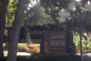 The Sharlot Hall Museum is the largest museum in the central territory of Arizona, and is dedicated to providing educational adventures in human and natural history. Founded by historian and poet Sharlot M. Hall in 1928, the Museum today explores the rich diversity of regional heritage through festivals, living history events, outdoor theater performances, changing exhibits, publications and research services.
 - Phippen Museum
4701 Highway 89 North
Prescott, AZ 86301
928-778-1385
George Phippen, first President of the Cowboy Artists of America, died in 1966, leaving behind a group of artists interested in creating a facility that specifically represented artists in the American West. In 1974, the George Phippen Memorial Foundation was formed to create a centralized venue that would fully support Western Art. With the assistance of a dedicated core of volunteers, the George Phippen Memorial Foundation began organizing fundraisers for the creation of their museum. The first annual Memorial Day Show was presented at the Prescott Public Library in 1974, featuring the finest of western sculptors and painters. For ten years, this show was the only financial means of the Foundation. - Smoki Museum
American Indian Art and Culture 147 N. Arizona Street Prescott, AZ 86304 928-445-1230 The museum houses irreplaceable collections of prehistoric and contemporary pottery, prehistoric jewelry and stone artifacts. The Smoki Museum exhibits also include an outstanding collection of Southwest basketry and kachinas. Among the museum's many valued collections are artist Kate Cory's numerous photographs, paintings and documents.
Prescott Area Golf Courses back to the top
- Antelope Hills North and South Courses - 1 Perkins Drive, (Perkins Drive and Highway 89) Prescott, AZ 86305. 928-776-7888. North Course Par 72, 6,844 yards, R72.1, S 128. South Course Par 72, 7,014 yards, R71.3, S 124. Considered one of Arizona's best affordable golf courses. Antelope Hills is an upscale 36 hole municipal facility including a restaurant, full-line golf shop and natural grass driving range.
- Prescott Golf and Country Club - 1030 Prescott Country Club Blvd. Dewey, AZ 86327. 928-772-8984. 13.5 miles east on Highway 69, right on Prescott Country Club Blvd. Par 70, 6,783 yards, R 64.3, S 109.
- Quailwood Greens Gold Course - 11750 East Highway 69, Dewey, AZ 86327. 928-772-0130. 14.4 miles east on Highway 69, right on Village Circle. Par 70, 5,800 yards, R 64.1, S 109.
- StoneRidge Golf Course - 1601 North Bluff Top Road, Prescott Valley. 928-772-6500. 7.3 miles east on Highway 69, right on Stoneridge. Par 72, 7,034, R 71.2, S 132. Nestled in the heart of Northern Arizona, StoneRidge Golf Course offers players scenic views and more than 350 feet of dramatic elevation changes from the highest tee to the lowest green. The 7,034-yard, par 72 daily fee course is carved out of the spectacular stone ridges and boulder outcroppings of Prescott Valley.
- Hassayampa Golf Club - 2060 Golf Club Lane, Prescott, AZ 86303 (928) 445-0009 Par 71, 6,660 yards, R 71.2, S 134 Private, Members Only: 18-hole, 7,000 yard, Tom Weiskopf signature designed course encompassing ponderosa pines, mountain streams and rock outcroppings.
- Prescott Lakes Golf Club - 315 East Smoke Tree Lane, Prescott, AZ 86301. 928-443-3500 Par 72, 7,216 yards, R 72.7, S 132. Private, Members only. Prescott Lakes Golf Club is the premier golf experience in Northern Arizona. Come experience our Hale Irwin designed championship, par 72, 7216-yard course. Tournament and event packages available. Experience "Troon Golf" in Prescott, Arizona.
- Talking Rock Golf Club - Information Center (877) 922-4440 Par 72, 7,350 yards, R 73.2, S 130. Private, luxury golf community near Inscription Canyon with an 18- hole, championship Jay Morrish designed course and state of the art practice facility. Located just 12 miles outside of Prescott, Arizona and in the shadow of Granite Mountain.
Public Courses
Private Courses
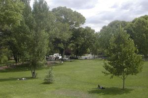
Prescott Area Parks and Recreation back to the top
- Acker Park: 421 S. Virginia St.
Features hiking trails, picnic areas, restrooms, children's play area, public art projects. - Badger Park: Corner of Ruth and Whipple
Features playground, ramada, picnic tables. - Flinn Park: 280 Josephine
Features ramada, picnic tables, softball/baseball field, basketball court, playground, restrooms. - Granite Creek Park: 554 N. Sixth Street
Features ramada, picnic tables, barbecue grills, horseshoe pits, walking course or jogging trail, restrooms. - Goldwater Lake: 1000 Goldwater Lake Park Click here for virtual tour Features boat ramp, fishing, ramada, barbecue grills, playground, fishing pier, horseshoe pits, volleyball court, picnic tables, restrooms.
- Heritage Park: 1497 Heritage Park Rd, (928) 708-0795
Features softball fields, snack bar, restrooms, ramadas, picnic tables, bleachers, hiking, access to Willow Lake. Also, home of the Heritage Park Zoo. - Ken Lindley Field and Park: 702 E.Gurley, (928) 771-5917 Click here for virtual tour
Features softball/soccer/football fields, tennis courts, ramada, picnic tables, playground, restrooms, concession stand. - Leroux Mini-Park: 536 W. Leroux St.
- Lynx Lake: Click here for virtual tour
- Peppertree Park: 220 W. Delano Click here for virtual tour
Features playground, picnic table. - Pioneer Park: 1200 Commerce Drive Click here for virtual tour
Features softball/soccer/baseball/football fields, jogging, horse, bike/hiking trails, concession stand, restrooms. - Prescott Activity Center: 824 E. Gurley, (928) 445-5291
Features multi-purpose community center, gymnasium, meeting rooms, restrooms. - Roughrider Park: 621 N. Washington Street, (928) 771-5918
Features athletic fields, tennis courts, restrooms, concession stand. - Stricklin Park: 1751 Sherwood Dr.
Features 5 acres of preserved forest land with historic trails. - Watson Lake Park: 3101 N. Highway 89 Click here for virtual tour
Features camping sites, boat ramp, fishing, ramadas, picnic tables, barbecue grills, restrooms, playground. - Watson Woods - Location: North Highway 89. One hundred and forty acres of riparian habitat, with trails, bird watching areas, and Little League field.
- Willow Creek Park: 3181 Willow Creek Rd, (928) 445-1734
Features ramada, softball field, horseshoe pits, barbecue grills, restrooms. - American Legion Park - 8569 East Yavapai Road - 2.5 acres Barbeque grills, playground equipment, ramadas, restrooms, lighted horseshoe pits.
- Antelope Park - 6933 North Cattletrack Road - 10 acres Playground equipment, ramadas, restrooms, walking path, multi-use fields, footbridge.
- Community Center Park - 9360 East Manzanita Circle - 4.5 acres Barbeque grills, open turf area, playground equipment, ramadas, restrooms, located next to the CASA Senior Center.
- Fain Park - 2200 North 5th Street - 100 acres Barbeque grills, bridge, fishing lake, ramadas, restrooms, sidewalks, paths, historical artifacts, including a refurbished stamp mill. More than 80 acres of the park are still in their natural state. Swimming, campfires, and overnight camping are not allowed.
- George Andersen Park - 9500 East Superstition Drive - 5.5 acres Barbeque grills, open turf area, playground equipment, ramada, restrooms, walking path, multi-use athletic field, basketball hoop.
- Mountain Valley Park - 8600 East Nace - 69 acres Barbeque grills, playground equipment, ramadas, restrooms, walking path, Mountain Valley Splash outdoor aquatic center, skatepark, multi-use lighted and unlighted athletic fields, concession stand, basketball courts, sand volleyball courts, located next to the Boys and Girls Club of Central Yavapai.
- Overlook Park - 6935 East Lynx Wagon Road - 1.4 acres Picnic tables; scenic view of Fain Park and Barlow-Massicks House
- Skatepark - Mountain Valley Park, 8600 East Nace Skatepark facility for skateboards and inline skaters.
- StoneRidge Neighborhood Park - 1800 North Fence Line Drive - 1.5 acres Playground equipment, picnic area, open turf
- Sunflower Park - 7240 North Sunflower Lane - 4.5 acres Barbeque grills, playground equipment, ramada, restrooms, walking path, multi-use athletic field, basketball hoop.
- Tonto Park South - 4050 North Tonto Way - 2.2 acres Open turf area, playground equipment, ramada, restrooms, Rotary Club rose garden.
- Tonto Park North - 4700 North Tonto Way - 2.5 acres Barbeque grill, playground equipment, open turf area, ramada, restrooms.
- Urban Forest - 8700 Lakeshore Drive - 12 acres Water features, ramadas, restrooms, walking path; many of the 100 trees at the Urban Forest have been donated in remembrance of special people or events, and a nearby kiosk holds commemorative plaques.
- Viewpoint Park - 7301 East Park Ridge Drive - 12.5 acres Planned: Barbeque grills, playground equipment, ramadas, restrooms, walking path, paved & lighted parking lot, basketball courts, soccer field, open turf area.
Prescott Parks
Prescott Valley Parks
Chino Valley Parks back to the top
- Aquatic Center - 1615 N. Road 1 East - Open Memorial Day through Labor Day No coolers, picnic baskets, or lawn chairs. Food or beverage allowed in the concession area only
- Center Street Park – Corner of Road 1 West and Center Street Recreational amenities under construction, may include a playground, walking trails and covered picnic tables.
- Community Center Park - 1 block east of Highway 89 on corner of Perkinsville Road and Road 1 East. Recreational amenities include Aquatic Center (and ramada 16' x 16'), Little League Field - 1, Skate Park, Ramada (45'x20'), Playground, 3 regulation-size softball fields, 1 regulation-size baseball field, 3 regulation-size junior soccer fields, 1 regulation-size adult multi-use field (soccer, football, etc.)
- Memory Park - 1020 W. Palomino Road on Road 1 West There are a variety of trees shading 2.4 acres of grass with a ramada and restrooms, playground, barbecues, horseshoe pits, bocce, basketball courts and Veteran's Memorial.
- Old Home Manor Ball Fields - 2100 Old Home Manor Drive off Perkinsville Road. Consists of 880 acres of mostly undeveloped land with a 3.75 acre, regulation-size baseball field which doubles as a special events location.
- Quail Ridge Park - North on HWY 89, left on Road 5 North, Left on Gambels Ridge Drive to 2725 West Gambels Ridge Drive. Presently there exists 2.4 acres of softball fields, a playground, restrooms, and rentable ramada with barbecues.
- Susan A. Williams Equestrian Center - North on HWY 89 right on Perkinsville Road 1.25 miles to 2208 Equestrian Way in Old Home Manor Restrooms and Rodeo Arena
Prescott Area Lakes back to the top
- Goldwater Lake - 1000 Goldwater Lake Park. North on Senator Highway (Mount Vernon Street). Travel north on Senator Highway about 4 miles to lake entrance on right. Goldwater Lake offers fishing, canoeing, and nature trails. It features a 15-acre lake with dock, boat launch, restrooms, ramada, playground equipment, picnic tables, sand volleyball court and horseshoe pits.
- Lynx Lake - Travel east on Hwy 69 a few miles past the 89/69 interchange to Walker Road. Turn right on Walker Road and follow sign to Lynx Lake. Lynx Lake is one of the most popular recreation areas in central Arizona. Located in the ponderosa pine forest, it is a serene 55-acre lake with trout fishing, boating, hiking, mountain biking, horseback riding, archaeological sites, and bird watching. Access to the lake has been provided for the physically challenged. Only electric motors are permitted on the lake.
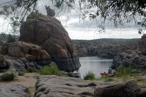
- Watson Lake - Four miles north of downtown on Highway 89, this beautiful park allows access to Watson Lake and the boulders of the Granite Dells.
- Willow Lake - Located at 1497 Heritage Park Rd. East off Willow Creek Road, north of Willow Creek Park. This is the access to Willow Lake as well.
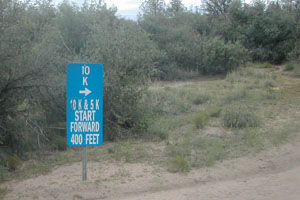
Prescott Area Hiking Trails back to the top
- Thumb Butte - trail 33
Permitted Uses: hiking
Difficulty: moderate
Hiking Time: 1 hour
 This Prescott, Arizona landmark is one of the most popular hiking areas, and is located just three miles west of downtown Prescott. Head west on Gurley Street 2.5 miles to Thumb Butte Road. Continue northwest for 1.5 miles to the recreation site and parking area. There is a day-use fee of $2.00 per vehicle. The 1.75-mile loop trail is paved and a bit steep at the start, but the views from the top are worth it.
 - Groom Creek Loop - trail 384
Permitted Uses: hiking, biking and motorized vehicles less than 40 inches wide
Difficulty: easy
Hiking Time: 3.5 hours
There is little elevation gain (500 feet), so this is a great 6-mile loop hike for almost everyone. Maverick Mountain and Mt. Tritle provide a beautiful backdrop to this trail that winds through lush vegetation along the Hassayampa River's upper basin. From downtown Prescott, head south on Mount Vernon Avenue. Continue south from Prescott approximately six miles to Groom Creek. Just beyond Groom Creek turn right on the dirt road to Wolf Creek campgrounds. Trail 384 crosses the road within .4 miles. - Prescott Peavine Trail
Permitted Uses: hiking, biking, and equestrian
Difficulty: easy
Hiking Time: variable
The "Rails to Trials" project helped form this winding trail that was once the route for the Santa Fe, Prescott and Phoenix railroad. The trail covers some of the most beautiful scenery in Yavapai County. It meanders through lush riparian areas, through the beautiful Granite Dells, above Watson Lake, and towards open rangelands. Total length is 9.2 miles round-trip, however you can leave a car at Hwy. 89A, which will make the distance about 4.6 miles. Drive east on Gurley Street from downtown Prescott to the Hwy. 89/69 intersections. Take Hwy. 89 north to Prescott Lakes Parkway and turn right. Then take the first left onto Sundog Ranch Road, and then left into the trailhead parking lot. - Little Granite Mountain - trail 37 and loop to Granite Basin Lake
Permitted Uses: hiking, bicycling (non-motorized), and horseback riding
Difficulty: moderate
Hiking Time: 1.5 hours
This trail provides spectacular panoramic views of Skull Valley, Prescott, Sugarloaf Mountain, and the western end of the Sierra Prietas. For a loop hike, drop a car at Granite Basin Lake. Take trail 37 from Iron Springs trailhead to the Clark Spring Trail turnoff, which takes you to the lake. From downtown Prescott head north on Montezuma, which will turn into Whipple Street. Follow Whipple to Miller Valley, Willow Creek, and Iron Springs road intersection. You will continue straight on Iron Springs road 6.2 miles. The trailhead is 3.2 miles west of the turnoff to Granite Basin Lake. - Lynx Creek Ruin Trail
This is an easy hike of about 0.75 miles. At the end of the trail, there is an interpretive area overlooking a prehistoric ruin of ancient Indian culture. Horseback riding and motorized vehicles are not permitted. The views are great. Take Route 69 to Walker Road. Turn left and proceed about 5 miles to the north end of Lynx Lake. Travel another mile to the entrance to the south end of the lake. - Acker Park Trails
Multi-use hiking trails with interpretive signs, restrooms, and views. Located at 421 S Virginia Street. Acker Park Trails Map (pdf, 372.7 kb) this map shows the various Acker Park trails. - Goldwater Lake Trails
North Shore (0.26 mile) and Bannon Creek Trails (0.6 miles) are two easy multi-use trails at Goldwater Lake. To reach Goldwater Lake Park, drive south on Mount Vernon Street (becomes Senator Hwy) about 4 miles to the entrance of Goldwater Lake Park, turn right and park in designated parking. There is a $2 parking fee. Goldwater Lake Trails Map (PDF, 1019.2 kb) this map shows the various Goldwater Lake trails. - Hassayampa Trails Map (PDF, 557.3 kb)
This maps shows the Hassayampa Trials, which include the Aspen Creek Trail, Butte Creek Trail and Rancho Vista Trail. - Aspen Creek Trail
This one-mile trail follows a portion of Aspen Creek while paralleling the Hassayampa golf course. Limited parking can be found along Middlebrook Rd. Please do not park on Poplar Drive. - Butte Creek Trail
Trail #321 begins at Stricklin Forest Park on Sherwood Drive. This trail parallels Butte Creek, westbound to the Prescott National Forest, and runs partially through a scenic canyon. The City portion is 1.3 miles, but the trail continues into the Prescott National Forest and connects to a larger trail system. - Rancho Vista Trail
Trail # 387 is one-mile trail is located in the southwest corner of the City, and connects to the comprehensive trail system on the Prescott National forest. There is parking for two vehicles at the end of Rancho Vista Drive. - Greenways Trail System
There are approximately 1.5 miles of multi-use trails along Prescott's Granite Creek, and Miller Creek that lead to/through downtown Prescott, and to Granite Creek Park. These trails have a large transportation emphasis, and future expansions are planned. Greenways Trail System Map (PDF, 803.6 kb) this map shows the Downtown Greenways Trail System. - Granite Creek Park
Park map shows walking trail around the park and connecting to Greenways Trails. Granite Creek Park Trail System Map (PDF, 230.6 kb) this map shows the Granite Creek Park Trail System. - Watson Lake
 Approximately one mile in length but can be extended by connecting to the Peavine. There is a $2 parking fee. Watson Lake Trails Map (PDF, 183.3 kb) this maps shows the Watson Lake Trails.
 - Willow Lake
This 3.5-mile trail encircles a portion of Willow Lake above the high water mark. Access is from Heritage Park, Willow Lake, and Willow Creek Park. Shown on the NE Prescott Trails map. Willow Lake Trails Map (PDF, 206.3 kb) this maps shows the Willow Lake Trails. - Lower Granite Creek Discovery Trail
This one-mile trail follows the western shoreline of Watson Lake, and connects the highway overlook to the Prescott Peavine Trail. It traverses the scenic southern backwater portion of Watson Lake. Shown on the Watson Lake Park and NE Prescott Trails Maps. - Prescott Peavine National Recreation Trail
This is one of the few Rails-to-Trails projects in Arizona. There are outstanding views of Watson Lake and Granite Dells, as well as wildlife viewing. Walk, hike, bike or horseback along this four-mile trail that was originally built by the Santa Fe Railway in 1893. The Peavine connects with the Iron King Trail for another four-mile trek along more railroad bed. Take Hwy 89 to Prescott Lakes Parkway, then to Sundog Ranch Road. Shown on the NE Prescott Trails Map. - Heritage Park/Willow Lake Trails
This map shows the Peavine and Iron King Trials, the Lower Granite Creek Discovery Trail and the Willow Lake Trail. There is a $2 parking fee at Willow Lake Park. Willow Lake Trails Map (PDF, 206.3 kb) this maps shows the Willow Lake Trails. - Embry Riddle/Jan Alfano Trails
Approximately 1.5 miles connecting the Heritage/Willow Lake trails to the Pioneer Park Trail system. - Pioneer Park Trails
A series of color-coded trails ranging in length form 1.68 miles to 6.08 miles. Located across Commerce Drive from the Pioneer Park ball field complex. Pioneer Park Trails Map (PDF, 423.3 kb) this maps shows the Pioneer Park Trails. - Prescott Circle Trail
Although not fully connected yet, the Circle is rapidly closing and will include trails from the City of Prescott, Prescott National Forest and Yavapai County for a 26-mile loop around the City. It will be a multi-use trail with a few camping locations along the way. Prescott Circle Trail Map (PDF, 1097.9 kb) this map shows the Prescott Circle Trail.